Wildfire
Table of Contents
A forest fire or wildfire is an unplanned fire, a term which includes grass fires, forest fires, and scrub fires either man caused or natural in origin. According to USGS, a forest fire is defined as combustion, marked by flames or intense heat, in natural, settings, often ignited by lightning or human activities and poses a growing threat to most regions of the United States. Though often a beneficial occurrence, fires are frequently suppressed by various agencies to prevent structural loss. This suppression of wildfires/forest fires, however, eventually leads to more severe fires, as vegetation becomes denser.
Though structures may be destroyed or heavily damaged by wildfires/forest fires, the long-term secondary effects may be of more consequence. These include erosion, landslides and flooding, the introduction of invasive species, and changes in water quality in the surrounding areas.
Background
Wildland Urban Interface
A wildland urban interface is essentially the area where housing and natural vegetation meet. This landscape is particularly vulnerable to wildfire and is the fastest growing land-use type in the U.S. [1].
Types of wildland fires
- A surface fire is the most common type and burns along the floor of a forest, moving slowly and killing or damaging trees.
- A ground fire is usually started by lightning and burns.
- Crown fires spread rapidly by wind and move quickly by jumping along the tops of trees.
Environmental Factors
Fire behavior is influenced by three primary environmental factors. These are fuel, weather, and topography.
- Fuel: The material that ignites and supports combustion. On the Daniel Boone National Forest in Kentucky, the fuel is primarily hardwood leaf litter on the forest floor. The continuity, arrangement, and fuel bed depth all influence fire intensity. The moisture content of the fuels is the principle factor determining whether they are available for combustion. Small fuels (leaves, needles, grass) respond most quickly to changes in temperature and humidity. Large fuels (branches, logs) are most affected by periods of drought after which they can significantly increase fire severity.
- Weather: Weather is typically the most critical factor influencing fire intensity and spread. Temperature, relative humidity, precipitation, and wind all affect the moisture content of the fuels, influencing availability. Additionally, wind provides the oxygen needed to sustain combustion, as well as most of the energy needed for fire spread. The Daniel Boone National Forest and its cooperators maintain a network of fire weather stations in and around eastern Kentucky which help us to determine fire danger and potential fire behavior.
- Topography: Topography refers to the landscape of a given area. Steep slopes offer greater potential for increased fire intensity than flat ground. Additionally, steep slopes make fire suppression more difficult by limiting strategies and tactics which can be utilized. South and southwest facing slopes typically will have lower fuel moisture regimes as a result of solar heating. Topographic features which channel wind and heat energy such as chutes, saddles, and box canyons all are potentially dangerous situations for firefighters.
Fuel Characteristics
There are 4 primary types of fuel for fires: grass, shrub, timber litter, logging slash. A fuel’s propensity to burn is largely based on the following characteristics:
- Moisture content:
- Dryer fuel has a low moisture content is more likely to catch fire.
- Fuel that has a higher moisture content is less likely to ignite.
- Size and shape:
- Light fuels such as shrubs, grasses, leaves, and pine needles burn rapidly and are quickly ignited, as they are surrounded by
plenty of oxygen. Fires in light fuels spread rapidly but burn out quickly, are easily extinguished, and fuel moisture changes more rapidly than in heavier fuels. - Heavy fuels such as limbs, logs, and tree trunks (any fuel one-half inch or larger in diameter) warm more slowly than light fuels, and the interiors are exposed to oxygen only after the outer portion is burned.
- Light fuels such as shrubs, grasses, leaves, and pine needles burn rapidly and are quickly ignited, as they are surrounded by
Location + Past Events + Extent
The Kentucky Division of Forestry tracks wildfire occurrence in Kentucky and provided data on past wildfire in the KIPDA Region between 2000-2019. This data is displayed in the dashboard below.
How to use the dashboard:
- Use the county drop down to select your county of interest.
- Hover over the map to zoom in (+) or search for a specific location.
- Hover over wildfire dots to see more information about a specific fire.
- To see full spreadsheet, click view data here.
Source: Kentucky Division of Forestry
Wildfire Extent
While 164 wildfires have occurred in the KIPDA region since 2000, the average size of these fires is less than 7 acres, and the median number of acres burned is 2. The greatest number of acres burned is listed next to each county.
- Bullitt County
- 10/21/2010: 250 acres burned
- Henry County
- 3/4/2009: 97 acres burned
- Oldham County
- 3/15/2000: 25 acres burned
- Shelby County
- 2/29/2004: 20 acres burned
- Spencer County
- 3/11/2003: 26 acres burned
- Trimble County
- 3/15/2014: 18 acres burned
Probability
Occurrence
As shown in the dashboard above, there are small fires every year in the KIPDA region. Typically, the term wildfire signifies a large, destructive fire. Only one incident in the past 20 years, the Knob Creek Fire, burned more than 100 acres. Therefore, while small fires happen every year, a fire over 100 acres has less than a 5% chance of occurring in the KIPDA region in any given year. A breakdown of fires by county is shown below.
- Bullitt County: 122 fires/ 20 years= 6 wildfire events annually
- Henry County: 19 fires/20 years= 1 wildfire event annually
- Oldham County: 1 fire/20 years=.05 wildfire events annually or 5% chance of an event occurring annually
- Shelby County: 13 fires/20 years=.7 wildfire events annually or 70% chance of an event occurring annually
- Spencer County: 3 fires/20 years=.15 wildfire events annually or 15% chance of an event occurring annually
- Trimble County: 6 fires/20 years=.3 wildfire events annually or 30% chance of an event occurring annually
Climate Change
The occurrence and frequency of wildfires is influenced by the occurrence and frequency of both extreme heat and drought. The rising of the average global temperature is increasing the intensity and duration at which droughts occur, meaning that there are longer periods of time where the conditions for wildfires are optimal. [2] Dry vegetation, caused by heat and lack of precipitation, fuels wildfires and forest fires, prolonging their duration and impact.
Kentucky has experienced more drought and drought like conditions in the past few years. Scientists expect the Midwest to experience more flash droughts. [3] In September of 2019 there were 107 wildfires reported by the Kentucky forestry division. September is typically a month that does not have any fires, let alone that many. It is expected that the state will see more wildfires in the summer and fall due to climate change. [4] Experts say that the state is long overdue for another forest fire, so the probability of a forest fire occurring is increasing, as well. [5]
Overall Probability
While the probability of a large event (over 200 acres) happening is low to moderate, the probability of a wildfire of any size happening is high for all KIPDA counties because of past occurrences.
Impact + Vulnerability
Impact
The impact of past wildfire events between 2000 and 2019 is shown in the table below. No deaths or injuries have been associated with wildfires in the region. The primary impacts of wildfire in the region relate to fire staff time. The number of staff used for an event and associated suppression costs are shown in the table. In a few instances, structures or pieces of structures were damaged. Those costs are shown under value of lost structure. For the full data set, click the view data here button.
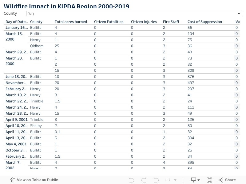
Source: Kentucky Division of Forestry
Vulnerability
Dense housing development that borders natural vegetation creates a wildland urban interface and can substantially increase wildfire risk. Therefore, an area’s land use can help communities understand wildfire risk areas. Click on the button below to view the 2019 National Land Cover Database clipped to the KIPDA HMP counties. The National Land Cover Database provides nationwide data on land cover and land cover change at a 30m resolution with a 16-class legend based on a modified Anderson Level II classification system. NLCD 2019 represents the latest evolution of NLCD land cover products focused on providing innovative land cover and land cover change data for the Nation. [6]
Wildfires can severely impact air quality and cause difficulty breathing. This can have an outsized impact on those who have pre-existing lung conditions such as asthma or COPD. For those with heart disease, rapid heartbeat and fatigue may be experienced more readily under smoky conditions. Wildfires can also cause fatalities.
Wildfires can cause utility damages and outages; lead to property damage and loss; adversely impact critical infrastructure; release hazardous materials; and damage farmers’ crop and livestock.
Wildfires can damage and destroy wildlife habitats. Ash and other contaminants from the wildfire can settle in streams and pollute water quality.
Data Limitations
Wildfires are recorded at the county level, and therefore KIPDA’s analysis is conducted primarily at the county level.
Hazard Vulnerability Analysis Summary
While small wildfires are frequent in KIPDA’s counties, they rarely cause significant damage. Suppression costs for the entire region from 2000 to 2019 totaled less than $18K, and the value of lost structures totaled approximately $30K. Even the largest (200+ acre) fire within the past twenty years, the Knob Creek Fire, did not cause the loss of any structures and had suppression costs less than $400. Because of the impact and extent of past events, the KIPDA region’s vulnerability to wildfire is low to moderate.
It should be noted that areas that are more densely populated such as Shepherdsville, Shelbyville, and La Grange are more likely to experience a costly, dangerous event because they contain a significant built environment.
- Between 2000 and 2019, 677 acres in Bullitt County burned due to wildfire.
- Bullitt County experienced 122 fires/20 years= 6 wildfire events annually.
- Bullitt County experienced a 250-acre fire, the Knob Creek Fire, in 2010. This fire did not result in significant suppression costs or property losses.
Because of these factors, Bullitt County experiences low to moderate vulnerability to wildfires. Because each of its cities contain clusters of building stock, it can be assumed that Bullitt County’s cities experience low to moderate vulnerability to wildfires as well.
- Between 2000 and 2019, 213 acres in Henry County burned due to wildfire.
- Henry County experienced 19 fires/20 years= 1 wildfire event annually.
- Henry County experienced a 97-acre fire in 2009. This fire did not result in significant suppression costs or property losses.
Because of these factors, Henry County experiences low to moderate vulnerability to wildfires. Because each of its cities contain clusters of building stock, it can be assumed that Henry County’s cities experience low to moderate vulnerability to wildfires as well.
- Between 2000 and 2019, 25 acres in Oldham County burned due to wildfire.
- Oldham County experienced 1 fire/20 years=.05 wildfire events annually or 5% chance of an event occurring annually.
- Oldham County only experienced 1 fire in 20 years. This fire did not result in significant suppression costs or property losses.
Because of these factors, Oldham County experiences low to moderate vulnerability to wildfires. Because each of its cities contain clusters of building stock, it can be assumed that Oldham County’s cities experience low to moderate vulnerability to wildfires as well.
- Between 2000 and 2019, 74 acres in Shelby County burned due to wildfire.
- Shelby County experienced 13 fires/20 years=.7 wildfire events annually or 70% chance of an event occurring annually.
- Shelby County experienced a 20-acre fire in 2004. This fire did not result in significant suppression costs or property losses.
Because of these factors, Shelby County experiences low to moderate vulnerability to wildfires. Because each of its cities contain clusters of building stock, it can be assumed that Shelby County’s cities experience low to moderate vulnerability to wildfires as well.
- Between 2000 and 2019, 35 acres in Spencer County burned due to wildfire.
- Spencer County experienced 3 fires/20 years=.15 wildfire events annually or 15% chance of an event occurring annually.
- Spencer County experienced a 26-acre fire in 2003. This fire did not result in significant suppression costs or property losses.
Because of these factors, Spencer County experiences low to moderate vulnerability to wildfires. Because each of its cities contain clusters of building stock, it can be assumed that Spencer County’s city experiences low to moderate vulnerability to wildfires as well.
- Between 2000 and 2019, 51 acres in Trimble County burned due to wildfire.
- Trimble County experienced 6 fires/20 years=.3 wildfire events annually or 30% chance of an event occurring annually
- Trimble County experienced a 18-acre fire in 2014. This fire did not result in significant suppression costs or property losses.
Because of these factors, Trimble County experiences low to moderate vulnerability to wildfires. Because each of its cities contain clusters of building stock, it can be assumed that Trimble County’s city experiences low to moderate vulnerability to wildfires as well.
References
[1] Samuel, Molly. (2021, July 8). More People are Moving to Places where Wildfire is a Growing Risk. National Public Radio. Retrieved from https://www.npr.org/2021/07/08/1014098351/wildfires-are-a-growing-risk-in-places-where-the-danger-used-to-be-minimal
[2] Trenberth, K. E., Dai, A., Schrier, G. V., Jones, P. D., Barichivich, J., Briffa, K. R., & Shefield, J. (2013). Global warming and changes in drought. Nature Climate Change, 4(1), 17-22. doi:10.1038/nclimate2067
[3] Kratzenberg, J., & *, N. (2019, October 03). Drought declarations issued throughout Kentucky. Retrieved July 24, 2020, from https://
www.lanereport.com/117661/2019/10/drought-declarations-issuedthroughout-kentucky/
[4] Velzer, R. (n.d.). Drought Fueling Hazardous Kentucky Wildfire Season. Retrieved July 24, 2020, from https://www.wkyufm.org/post/droughtfueling-hazardous-kentucky-wild\ire-season
[5] Stunson, M. (n.d.). Just a trace of rain fell in Lexington this month. Will the Kentucky drought spread? Retrieved July 24, 2020, from https://www.kentucky.com/news/local/counties/fayette-county/article235179527.htm
[6] Multi-Resolution Land Characteristics Consortium (2021). NLCD 2019 Land Cover. [Data set]. National Land Cover Database. Retrieved from https://www.mrlc.gov/data?f%5B0%5D=category%3Aland%20cover&f%5B1%5D=region%3Aconus