Landslide
Table of Contents
Landslides are the downslope movement of rock, soil, or both under the influence of gravity. This type of mass movement and the type of earth material involved can vary. Landslides can occur in landscapes ranging from gentle slopes to steep cliffs. Velocity of landslide movement can also vary from slow to very rapid.
Background + Extent
What triggers landslides?
Landslides are the downslope movement of rock, soil, or both under the influence of gravity. Landslides occur when gravity exceeds the strength of earth materials that compose the slope.
Often landslides are triggered from a combination of activities including:
- Intense rainfall: Soil and rock material on slopes may have high moisture levels, increasing pore-water pressure, which destabilizes the slope and causes slides. Subsequently, surface-water erosion may also cause landslides.
- Earthquakes: Ground shaking during earthquakes can cause landslides in many different topographic and geologic settings.
- Water-level change: Rapid lowering of groundwater against a slope can trigger landslides, especially along dams, coastlines, reservoirs, and rivers. The pore pressure in soil or rock material may not be able to adjust to a sudden drawdown of water causing slope instability.
- Human activities: Many destabilizing activities may trigger landslides. These include vegetation removal, surface and underground mining, excavation of toe slopes, loading on a slope, and leakage from pipes.
- Geology: Easily weathered rock types and soils, especially on steep slopes, combined with the triggers listed above are susceptible to landslides.
How do landslides move?
How are landslides measured?
Data is currently unavailable related to a physical standard by which to compare landslide hazard events.
Location + Past Events + Impact
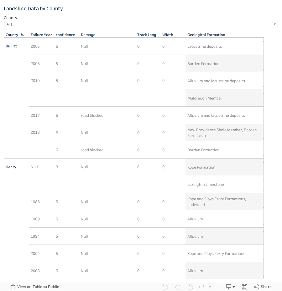
The following map displays landslide locations in the KIPDA region from the Kentucky Geological Survey. KGS determined possible landslide locations through local reports, LiDAR-derived digital elevation models, and aerial photos. A complete data breakdown can be found here [2].
Please note that the landslides shown on the map do not have the same confidence ranking. Confidence ranking indicates how likely it is that the landslide occurred, and it can range from 1, possible landslide to 8, definite landslide.
How to use the map:
- Select your county to just see its landslide locations.
- Hover your mouse over the dots to find more information about the landslide location – such as geologic formation, confidence level, etc.
- Hover your mouse over the map to zoom in and out and search for a location.
Local Reports
While the map and database above are incredibly helpful for identifying landslides across the region, it does not contain every landslide in the region nor hills/slopes that may soon collapse. Therefore, KIPDA staff requested local data on slope destabilizations and landslide from county staff. This information is displayed in the accordion below.
Bullitt County reported several slopes that may collapse:
- Cabin Creek Drive: A hill (located at 38.0469, -85.7221 with an elevation of 616.83 feet) above Cabin Creek Drive in Bullitt County is destabilizing at an alarming rate. Bullitt County Road Department has made several repairs; however, these are just stopgap measures, and the hill has continued to destabilize and erode the roadway. A substantial landslide event is likely without significant mitigation measures. If the hill does fully destabilize and cause a landslide event, part of the road below the hill would essentially be wiped out. This landslide would also take out an electricity line and a water main. In addition, this event would cut off electricity to 18 homes surrounding this road. Finally, such an event would also make the road impassible, and emergency services would be unable to reach those 18 homes.
- Holsclaw Hill Road (38.0664, -85.7374)
- Holsclaw Hill Road next to the Jefferson County line (38.0778, -85.7454, elevation: 885.87)
- Greenwell Ford Road (38.009, -85.545)
- Pauleys Gap Road in western Bullitt County near the Jefferson County line: A hill (located at 38.0427, – 85.8724 with an elevation of 416.69 feet) above Pauleys Gap Road in Bullitt County is destabilizing quickly. The hill sliding has caused significant erosion to Pauleys Gap Road. The Bullitt County Road Department has completed two extensive repairs; however, their work has been lost because the hill continues to destabilize and erode the roadway. The hill is on the verge of collapse into the roadway, and such an event would break the nearby watermain and cause the road to slide down the hill. That section of the roadway and any additional debris will dam Brier Creek, which is a blueline stream below the roadway. The Bullitt County Road Department estimates that debris removal and stream restoration following a landslide event could cost around $800,000.
Need more info.
No additional landslide events reported.
No additional reported landslide events.
No additional landslide events reported.
Need more info.
Probability
Occurrence
Since 1991, KGS has recorded 38 possible landslides in the KIPDA region. Please note that the map in the previous section includes all landslides within the KGS database, and therefore it shows 3 more events that occurred before 1991.
- Bullitt County: 7 events/30 years = .23 landslide events per year or 23% chance of a landslide event happening annually.
- Henry County: 6 events/30 years = .2 landslide events per year or 20% chance of a landslide event happening annually.
- Oldham County: 7 events/30 years = .23 landslide events per year or 23% chance of a landslide event happening annually
- Shelby County: 4 events/30 years =.13 landslide events per year or 13% chance of a landslide event happening annually.
- Spencer County: 5 events/30 years = .17 landslide events per year or 17% chance of a landslide event happening annually.
- Trimble County: 9 events/30 years = .3 landslide events per year or 30% chance of a landslide event happening annually.
Bullitt County is the only county with more than 1 confirmed failure event with damages. Bullitt experienced 3, Oldham experienced 1, and Trimble experienced 1.
Climate Change
Most landslides are caused by rainfall and snowmelt disturbing slope evolution, which in turn causes fractured rock masses to become unstable. Any way in which precipitation is increased will increase the likelihood of a landslide occurring. The way that climate change is affecting the hydrological processes of the Earth will result in an increase of landslide events in some regions.
Combined data from the National Climate Assessment and the Army Corps of Engineers predicts that that regions northeast, east and south of the Ohio River will experience an increase in precipitation in the form of rainfall by 40-50% by the year 2100. [3] [4] More rainfall in Kentucky means that the likelihood of a landslide event occurring is increased. Landslides are more prominent in Eastern Kentucky, but are also common in the Knobs and the Ohio River Valley areas, both of which are in the Kentuckiana region. [5]

Landslide Susceptibility
During Kentucky’s 2018 Hazard Mitigation Plan update, Kentucky Geological Survey (KGS) developed a landslide susceptibility map for the state in order to show which areas have greater landslide risk due to slope and geology. Click the button below to access the map.
A statewide landslide susceptibility model was developed in ArcGIS using two map layers: geology and slope. The geology and slope maps (raster images) were reclassified based on a matrix of weighted scores that were assigned to particular geologic formations and ranges of slope values (Table 2-5). The weighted score for slope doubled with each increasing slope range. The weighted score for the geology ranged from 10 to 40 depending on the rock type. Using the ArcGIS Weighted Sum tool, the newly reclassified values of both raster map layers were multiplied by an assigned weight and then values for both layers were added together (Eq. 2-1). In order to have slope be a greater influence on the susceptibility model, a 70 percent weight was assigned for slope and a 30 percent weight was assigned for geology.
Eq. 2-1
(geology reclass value × 0.30) + (slope reclass value × 0.70) = landslide susceptibility value
Using the summed cell values from the two layers, landslide susceptibility was manually classified into low, moderate, and high categories (Fig. 2-8). Classification was made by visually inspecting the map and by determining the distribution of existing landslides cataloged in the Kentucky Geological Survey inventory.
Table 2-5. Landslide susceptibility model matrix. Reclassification values for geology and ranges of slope values are in bold italic. A weighted value of 70 percent was assigned to slope and 30 percent to geology. The calculated cell values and classification breaks are in red, yellow, and green, which indicate low, moderate, and high susceptibility, respectively.

Overall Probability
Overall, the KIPDA HMP ranks the probability of a landslide occurrence as high because of past events, climate change, and landslide susceptibility.
Vulnerability & Impact
There have been no recorded deaths associated with landslides in the KIPDA region. However, if there was a large landslide event, people could suffer injuries or even death.
Direct costs of landslides include repair and maintenance of roads and property. Indirect costs are in the form of loss of tax revenue on property devalued because of the landslide, loss of real estate value in landslide-prone area, and costs associated with landslide’s impact on water quality. For example, the Kentucky Transportation Cabinet incurs direct costs of $20 million annually for landslides that damage roads.
Landslides can provoke associated dangers such as broken electrical, water, gas, and sewage lines and can disrupt roadways and railways.
Landslides can destroy habitats and injure wildlife. Debris flows from landslides can increase sediment loads in waterways, which impacts water quality.
Data Limitations
Landslides are not systematically recorded at the jurisdictional level, and therefore, risk is assessed at the county level.
Hazard Vulnerability Summary Analysis
Overall, the KIPDA region has a moderate vulnerability to landslide events. For a break down by county, please use the accordion below.
- Bullitt County has issues with slope destabilization at several locations across the county and has reported these issues to KIPDA.
- Bullitt County has reported roads being blocked due to landslide events in 2017 and 2018.
- The landslide susceptibility map demonstrates significant risk due to the county’s terrain.
Because of these factors, Bullitt County experiences moderate to high vulnerability to landslide events. Moreover, Bullitt County’s cities depend on county roads, which may be impacted by landslide events. If a county road experiences a landslide event that can impact residents’ ability to reach their respective city within Bullitt County. Therefore, it can be assumed that Bullitt County’s vulnerability assessment applies to its cities as well.
- The landslide susceptibility map shows pockets of high risk.
- Henry County has experienced 6 landslide events in the past 30 years.
- No past damage information is available for Henry County.
Because of these factors, Bullitt County experiences moderate vulnerability to landslide events. Moreover, Henry County’s cities depend on county roads, which may be impacted by landslide events. If a county road experiences a landslide event that can impact residents’ ability to reach their respective city within Henry County. In addition, landslides are not systemically recorded at the jurisdictional level, and therefore, risk is assessed at the county level. Therefore, it can be assumed that Henry County’s vulnerability assessment applies to its cities as well.
- The landslide susceptibility map shows pockets of high risk.
- Oldham County has experienced 7 landslide events in the past 30 years.
- Damage did occur following a 1996 landslide but data about this damage is not available.
Because of these factors, Oldham County experiences moderate vulnerability to landslide events. Moreover, Oldham County’s cities depend on county roads, which may be impacted by landslide events. If a county road experiences a landslide event that can impact residents’ ability to reach their respective city within Oldham County. In addition, landslides are not systemically recorded at the jurisdictional level, and therefore, risk is assessed at the county level. Therefore, it can be assumed that Oldham County’s vulnerability assessment applies to its cities as well.
- The landslide susceptibility map shows pockets of high risk.
- Shelby County has experienced 4 landslide events in the past 30 years.
- No past damage information is available for Shelby County.
Because of these factors, Shelby County experiences moderate vulnerability to landslide events. Moreover, Shelby County’s cities depend on county roads, which may be impacted by landslide events. If a county road experiences a landslide event that can impact residents’ ability to reach their respective city within Shelby County. In addition, landslides are not systemically recorded at the jurisdictional level, and therefore, risk is assessed at the county level. Therefore, it can be assumed that Shelby County’s vulnerability assessment applies to its cities as well.
- The landslide susceptibility map shows pockets of high risk.
- Spencer County has experienced 5 landslide events in the past 30 years.
- No past damage information is available for Spencer County.
Because of these factors, Spencer County experiences moderate vulnerability to landslide events. Moreover, Spencer County’s only city, Taylorsville, depends on county roads, which may be impacted by landslide events. If a county road experiences a landslide event that can impact residents’ ability to reach Taylorsville. In addition, landslides are not systemically recorded at the jurisdictional level, and therefore, risk is assessed at the county level. Therefore, it can be assumed that Spencer County’s vulnerability assessment applies to Taylorsville as well.
- The landslide susceptibility map demonstrates significant risk due to the county’s terrain.
- Trimble County has experienced 9 landslide events in the past 30 years.
- An embankment failure/collapse occurred following a 2016 landslide.
Because of these factors, Trimble County experiences moderate vulnerability to landslide events. Moreover, Trimble County’s cities depend on county roads, which may be impacted by landslide events. If a county road experiences a landslide event that can impact residents’ ability to reach their respective city within Trimble County. In addition, landslides are not systemically recorded at the jurisdictional level, and therefore, risk is assessed at the county level. Therefore, it can be assumed that Trimble County’s vulnerability assessment applies to its cities as well.
References
[1] National Geographic (2021). Landslide. Retrieved from https://www.nationalgeographic.org/encyclopedia/landslide/
[2] Kentucky Geological Survey (2021). Landslide Information Map [data set]. Retrieved from https://kgs.uky.edu/kgsmap/helpfiles/landslide_help.shtm
[3] Walsh, J., & Wuebbles, D. (2014). Precipitation Change. Retrieved from https://nca2014.globalchange.gov/report/our-changing-climate/ precipitation-change
[4] Hayhoe, K., Wuebbles, D. J., Easterling, D. R., Fahey, D. W., Doherty, S., Kossin, J. P., . . . Wehner, M. F. (2018). Chapter 2 : Our Changing Climate. Impacts, Risks, and Adaptation in the United States: The Fourth National Climate Assessment, Volume II. doi:10.7930/nca4.2018.ch2
[5] Lynch, M. (n.d.). Landslide Hazards in Kentucky [PDF]. Lexington: Kentucky Geological Survey, University of Kentucky.